
Decatur is a very industrial area.

There were two locks to get through before a planned stop back in Florence, AL. We heard from the lockmaster at the first lock that there was a tow at the second lock and a few pleasure crafts waiting. It was the Wilson Lock and 15 miles away, he thought we might just make it and be able to pass through with the other boats. I'm glad we didn't take any drastic actions to hurry our arrival, because the tow hadn't completed its passage and four other pleasure craft were still waiting. Two more arrived and we were delayed further when the lockmaster advised there was a malfunction and he had to wait for maintenance to fix it. It was over an hour before we all moved into the lock.

I posted about the Wilson Lock when Ron and I were making the trip up the river. At 95 feet, it is the biggest lock of the trip, but going down was different than going up and we were the last ones in, so right in front of the rear door, which turned out to be a wicket gate that came up from below.


As we went down, water flowed from the gate, creating a waterfall.


It was a long way up when the water was all out.

When the doors opened we were second to last in a parade of boats.


The Florence stop was quick. I had called and asked the marina dockmaster if I could pay her to borrow the courtesy car, even though we were'nt staying for the night. She remembered me and said I could use her car, which we did. Denise had arranged for my prescriptions to be filled there.
We went a few more miles and anchored for the night. We planned for an early start, actually, Geo always wants an early start because he's usually up before the sun, while I can easily sleep until well after the sun is up. It worked out for me, because again it was foggy.

At mile 217 of the Tennessee River we made the turn on to the Tenn-Tom Waterway. Actually, the Tenn-Tom starts at the mouth of the Tennessee on the Ohio River and runs 667 miles to Demopolis, AL where it meets the Black Warrior River.
This completed my side trip further up the Tennessee to Knoxville. In all, the Tennessee is navigable for 650 miles. I completed 620 of them, missing the first 25 because I went up the Cumberland to Lake Barkley and joined the Tennessee from there and the last 5 because downtown Knoxville is mile 645 and I didn't go all the way to mile 650.
The first part of the waterway off the Tennessee is a 39 mile canal that connects it to the Tombigbee River. We are now back in Mississippi.

Like all the other canals on this trip, there's not really much to see, so I took pictures of bridges.


There are 11 locks between here and Mobile. Eight of them in the first 150 miles. It took us 3 days to cover the 150 miles.
We did have some entertaining momemts though. As I came up behind a tow, I made the normal call and asked the tow captain if it would be possible to get a pass. He came back in the thickest southern accent you can imagine and said "anything is possible." I then asked if it would be advisable and he said "come on."

After I passed, he called and said, "see how easy that was."
Geo hasn't quit smoking yet and he tried to burn up my Skipper Bob's River Guide.

As we approached Columbus, MS, I started hearing and seeing Air Force fighter jets, lots of them. There was obviously some training going on as we would see a jet and then a few minutes later a couple more chasing the first one. I took lots of pictures, but its really hard to catch them. But then two came low right overhead.

Most mornings were foggy and cold. We arrived at this lock as early as possible.

Some old bridges.


We also came upon another deer crossing the river and had to slow down to not hit him.


For most of the time through Mississippi I did not have cell phone service. Maybe that's why someone had put this along the bank of the river.

A few miles south and east of Columbus, MS the waterway re-enters Alabama.
Late one afternoon, the temperature of the starboard engine started going up and eventually I had to shut it down. We continued on one engine and it was late before we reached a suitable anchorage.

Luckily, Geo was with me for the engine overheating problem. It turned out to be a worn out impeller in the engine cooling system and I had a spare. Getting the old one out was easy, but both of us tried to get the new one in and finally Geo was able to get it. This solved the problem.
I had read and seen pictures of a stretch of the river that is lined with white sandstone.


We found ourselves the first boat in a lock that eventually filled with seven more.

Most of these were bigger than Tranquility, but one was not.

And they were doing the loop.
All of these boats were going to cruise faster than us, so we let them by, but ended up locking through with them again the next day. It was helpful for them to be stretched out ahead of us because we could hear the radio call to tows and know when we were going to meet or overtake one.
One boat was a half mile or so in front of us and began an exchange with a tow captain. At one point the tow captain told him he was going to be in the way and when he asked where he should go, the tow captain told him to go on the sandbar. The pleasure boater thought he was kidding and then we heard the tow captain said he had no choice and he ran his barge into the bank to avoid hitting the pleasure boat.

He then called me and said to step on it and get past him, which I did.
We usually follow the Skipper Bob's guide to find suitable anchorages and this one turned out to be quite nice, but a little tight getting into.

We encountered a couple of unique boaters along the way.


Take a close look at this picture and you can see the skyline of Mobile.

The river runs right through downtown and the waterfront is all about shipping and ship building.
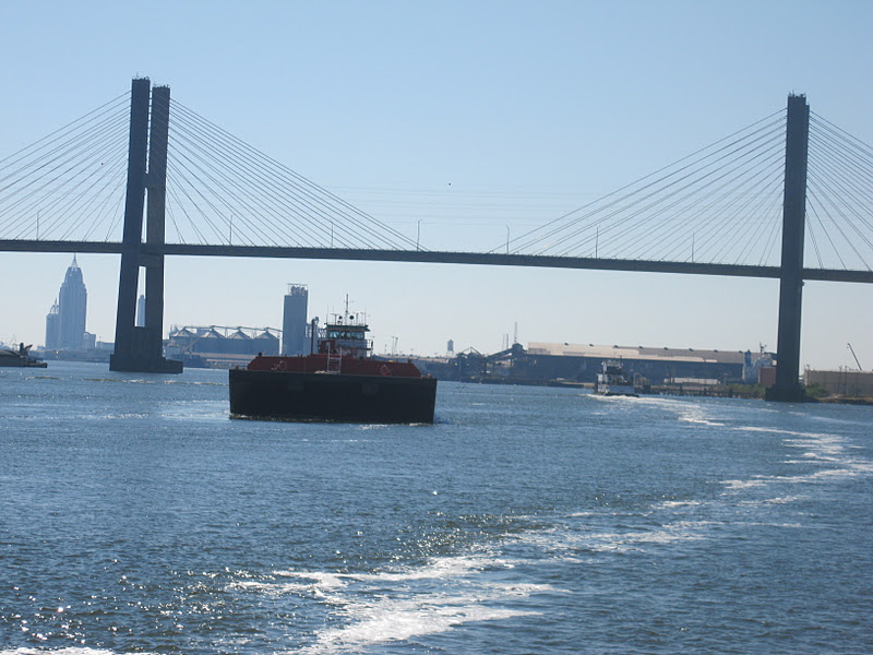


After a relatively short trip through downtown, we were heading into Mobile Bay.

It was 31 miles to the southeast corner where we would enter the Gulf Intercoastal Waterway, (GIWW).

The GIWW was right where the chart said it would be.

We called a marina that we had read had a good water front restaurant where we could watch the big Alabama-LSU game. Since we were still in Alabama, we figured it would be fun. There were even a couple of LSU fans. It was a good game, but not very exiting and LSU won.
We were only going 15 miles today, to Pensacola. Just a few miles from the anchorage we were back in Florida.

It doesn't look very promising for a Gulf crossing anytime this week and we have flights home on Nov 16th. We had to make a decision several days ago, in order to get decent flight prices, so we booked from Pensacola. Since we are already here, Geo has decided to rent a car and drive to Madeira Beach to take care of some business and check on his boat there. I have decided to keep going alone across the Florida panhandle to Carrabelle, where I have found a marina to leave the boat for awhile. Geo will drive back early next week to Carrabelle and then we will return the car in Pensacola and catch the flights home.
I will post once more when I get to Carrabelle. I'm not sure exactly when I will come back to make the Gulf crossing and finish the first loop.


